Showing posts with label Photos: Waikato. Show all posts

Sunday, April 10, 2011

Te Koutu domain

In the middle of Cambridge is quite a large, and easy to miss lake, Lake Koutu. This lake was farmed when Taupo erupted and blocked off a tributatry to the river Waikato. Of course, that's history from a long time ago - now the lake froms part of the domain, a picturesque spot to go for a walk, with, or without a dog.

There are various walks through the domain, and you can easily spend an hour meandering around to see half of it. Some pics:

Te Koutu Park Gates, Cambridge - April 2011

Te Koutu Lake, Cambridge - April 2011

Te Koutu Lake, Cambridge - April 2011

Te Koutu Lake, Cambridge - April 2011

Te Koutu Lake, Cambridge - April 2011

Te Koutu Lake, Cambridge - April 2011

Te Koutu Lake, Cambridge - April 2011

Te Koutu Lake, Cambridge - April 2011

Te Koutu Lake, Cambridge - April 2011

Band Rotuna, Te Koutu Domain, Cambridge - April 2011

Te Koutu Domain, Cambridge - April 2011

Olympia Flowforms by Iain Turnball - Te Koutu Domain, Cambridge - April 2011

Tuesday, February 8, 2011

Marokopa Falls

Not far from Sunday's first walk, lies Marokopa falls - again, an hour and a half's drive from Hamilton, and a 10 minute walk each way from the parking area. The forest is pretty standard fare - but the falls are well worthwhile, as the following photos atest to:

Marokopa Falls - 2011

Fungi

Marokopa Esplanade - 2011

Marokopa Esplanade - 2011

Of course, the falls aren't the only scenery around here. The drive is rather scenic:

Phone booth - Marokopa 2011

Horses near Marokopa - 2011

Marokopa to Kawhia route - 2011

Marokopa to Kawhia route 2011

Marokopa to Kawhia route - 2011

Sunday, February 6, 2011

Mangapohue Natural Bridge

Today's walk was a little further afield - about 150km away from my home in Hamilton, but a very worth drive.

The first destination was the Mangapohue natural bridge on Te Anga Road, about 25km away from Waitomo. The bridge is about 17m off the ground, and together with the gorge you walk through, forms the remnants of an ancient cave system. The walk itself is about 5 minutes, so not long at all.

A few photos:

Mangapohue Natural Bridge


Mangapohue Natural Bridge - Track with Swing Bridge

Mangapohue Natural Bridge - Track

Mangapohue Natural Bridge - Track

Mangapohue Natural Bridge

Mangapohue Natural Bridge

Mangapohue Natural Bridge
Once you've gone beneath the natural bridge, something else special is hiding in the same spot. Right inside these rocks for that matter - fossils!

Mangapohue Natural Bridge - Rocks

Mangapohue Natural Bridge - Fossillised shellfish

And few other things to take photos of too...

and a flower with a fly...

... a thistle with a bee...

Mmmm Blackberries

Blackberries - haul!
This has to be one of the best short tracks in the Waikato. Well worth a visit.

Monday, January 31, 2011

Pukemokemoke Reserve

The Pukemokemoke bush reserve is about 25 minutes drive from Hamilton, and the walk there is a similar length to the top (unless you do the longer Nor-East loop). It's a nice hidden away spot of bush, a historic pa site, and a good place to get a bit of exercise on a proper bush track. A map can be found further down this post.
Pukemokemoke Bush Reserve Sign


Pukemokemoke Bush Reserve  - Looking across entry bridge

The reserve was formed in 1993 after the land was donated by David Johnstone, and has undergone recent improvements. Since I was last here, new signs have been erected, and even a Gazebo generous donated by the Freegard family.


Pukemokemoke Bush Reserve - Log Hauler site with Gazebo
Of course, signs aren't the reason you come, nor is a gazebo, though it is the sort of facility I might make use of in the future. The real reason you'd come is that this is a nice patch of bush, some of it left from when the area was logged, and some regen, and convinient to town.

There are even a few old Kauri left, put please heed the warnings about cleaning shoes and gear because of Kauri dieback (Phytophthora taxon Agathis). Basic facilities are provided to clean your gear at the start of each track.


Pukemokemoke Bush Reserve - Kauri

In addition to aforementioned Kauri, the reserve also has all manner of other native trees, including large totara. The main track is a loop, you can depart in either left or right direction from the carpark. Should you go left, you'll climb up a steeper track, through the old Pa site and Kauri grove up to the Kawakawa grove. From here, you should ascend to the trig for worthwhile views, then back to the Kawakawa grove (this is a siding). Then, down to the Log Hauler site (where the above Gazebo stands), and back to the carpark.

Pukemokemoke Bush Reserve


Pukemokemoke Bush Reserve


Pukemokemoke Bush Reserve - view from trig tower


Pukemokemoke Bush Reserve - trig tower


Pukemokemoke Bush Reserve - Geodetic Survey Mark (Trig) A343

Pukemokemoke Bush Reserve (map is linked)


Saturday, January 29, 2011

Hamilton Lake

The weather this morning wasn't too bad, considering a cyclone has just passed over, but it was still rather windy this morning, so my walk was in a reliable place - Hamilton Lake.

Sadly, I didn't think to clear out my SD card this morning, so about 10 minutes into the 45 minute loop, I'd filled it up. Photos below however.

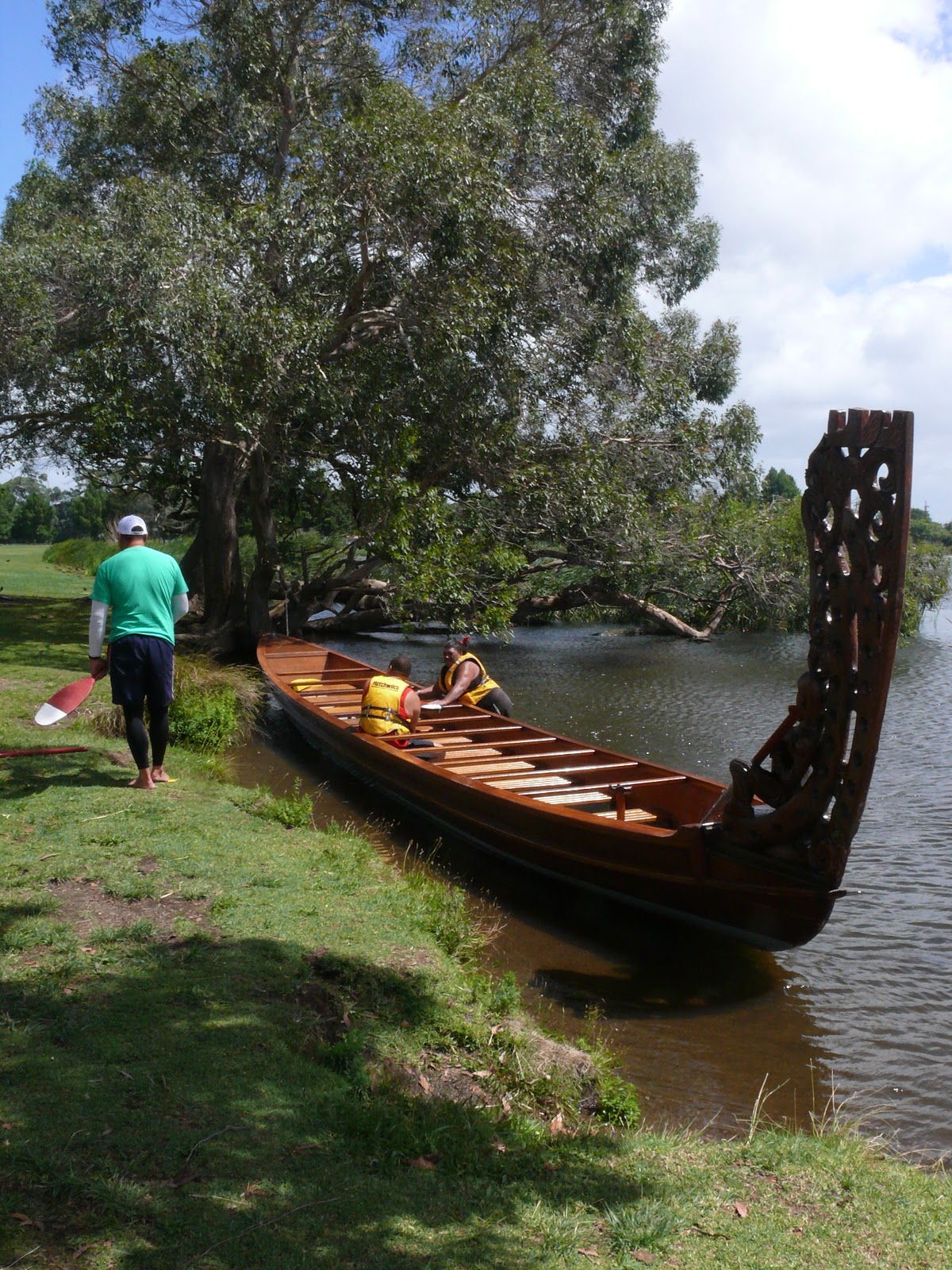
The wind made the lake look more like a sea, with spray all over the paths. What made things even more interesting was the Waka Ama racing which was talking place.


Waka Ama - Lake Rotorua (Hamilton Lake)

Waka Ama - Lake Rotorua (Hamilton Lake)

Waka Ama - Lake Rotorua (Hamilton Lake)

Waka Ama - Lake Rotorua (Hamilton Lake)

Ducks near Lake Rotorua (Hamilton Lake)

Sunday, January 16, 2011

Maungakawa Reserve / Te Waikato Sanitorium

My walk today was a little further afield - outside Hamilton, outside Cambridge even - to the Maungakawa Scenic Reserve, which also happens to be the site of the Te Waikato Sanitorium and incorporates the Guidex memorial park.


This is all that's left of the once sprawling facility, along with a few stray exotic plants.

Old Boiler house: Te Waikato Sanitorium
The property was first purchased by Daniel Thornton in 1886 from the local Maori, and, after his death, his wife had a homestead built on the ridge (in 1890), which was later, in 1902 purchased by government and utilised as a sanitorium for sufferers of tuberculosis. The site would be utilised after the first world war for recuperating soldiers, and dismantled and sold in 1922.

Some historic photos of the site:


Of course, nowadays, the site looks very different. The bush has regenerated, and there is a 30 minute track. I'm no good at taking photos in the bush, the light is difficult, but here are a few photos of the park none-the-less.

The Lions Club put this lookout up recently

Hard to imagine there was so much here in the past.

A very old sign. When the way up the hill was still by horse and cart, this was the spot to stop for a break.

And for that reason, the scouts put this bench up.


An interesting carving someone made...


All in all, this is a historic site that's well worth visiting, bush, birds, a picnic spot and history...